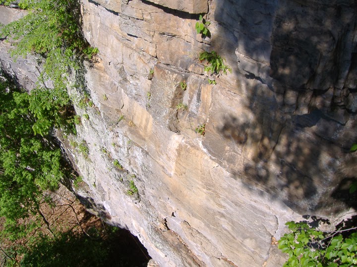
Eagle Rocks
This formation is one of the icons of the canyon, and is located just 2.2 miles from the Route 220 intersection on the south-east end of the canyon. Opposite the campground entrance is the grave of William Eagle, Revolutionary War hero and local legend.
Eagle Rocks is a cluster of vertical
limestone fins jutting from the flanks of Cave Mountain. The Rocks are blessed with a plethora of
cracks, aretes, dihedrals, and faces, vaguely reminiscent of Seneca in much the
same way that the Tetons are reminiscent of breasts. The 10th Mountain Division trained and climbed here, as
had God knows how many brave little naked red hunters and local sweethearts; exposed to the elements and subject at any time to any of a number of sudden,
perhaps catastrophic geological changes.
The Rocks are covered with
semi-detached flakes, stacks of loose stone, precariously-balanced blocks the
size of stoves. Trees, debris, and
indeed entire large portions of the numerous faces can and will fall off
without provocation or warning.
Apparently-solid rock can suddenly fracture and plunge earthward, taking
you with it and sucking your belayer right through the first quickdraw. Massive sections of the talus slope below can
shift or collapse without warning, including sections which have until then been
stable for years, centuries even.
Trails
were established by whitetail deer, black bear, local climbers and other
unstable forms of indigenous life, and cannot be counted on not to hurl you to
a painful and untimely death or even to get you to the crag and back again
without winding up like the Donner party.
Venomous snakes, stinging
insects, biting animals, and vicious plants can and likely will attack you for
absolutely no discernible reason, at any time, anywhere. Being outside is a risky business, and you
probably shouldn't do it if you are unwilling or unable to accept those risks
as your own responsibility.
Climbing Eagle Rocks is
especially dangerous, for the reasons noted above and many, many more. The face is spotted with old pins and ring
angles left behind by soldiers before the Second World War, some of them
psychotic killers, many of them unstable young men terrified by the enormous
exposure and pushed to the limits of sanity by bad food, homesickness, venereal
disease contracted from local girls, abuse from overbearing homophobic drill
instructors and the challenge of trying to follow driving instructions from the
locals. Almost all of them arrived and
departed equally inexperienced in the placement of protection (thus the
venereal diseases). A few, like Fred
Becky, went west and figured it out way up in Leavenworth, WA or out in the
Sierras.
More modern gear like rappel
anchors, face bolts, and cold shuts may have been and likely was installed by
drug-addled, brain-damaged trad climbers with a pathological resentment of
gymbies and newcomers, deeply-seated antisocial issues, no sense of personal
safety or respect for the sanctity of human life, and an addiction to Seneca Indian Pale Ale.
(Of course the author has no
personal knowledge of this possibility.)
No anchor, bolt, piton or
ring angle should be trusted to save your life.
Of course, removing these items, as well as found biners, gear laying on
ledges or left in cracks and pockets or anything
else that you didn't bring with you constitutes reckless endangerment,
vandalism, destruction of private property, and theft and the landowners as
well as the NFS will likely prosecute to the fullest extent of the law.
Don't steal our stuff. Not our
hardware, not our beta, not our projects, and not our gear. Lynching is socially embarrassing, and prison
is a bad place, worse even than Eagle Rocks, and you don't want to go
there. The coffee is horrible, there's
no Net Flix, and room service is something you really don't
want.
While Eagle Rocks are private
property, the family which owns it is pretty casual about access. They are also pretty casual about having the aging outhouses pumped or picking up trash or mowing. Camping is pick your spot and do as you please, fees are collected sporadically, usually late in the morning, by the aging landowner. Climbing is your call and your liability: you cross the river, you take responsibility for yourself.
There is no real record of
who first climbed the trad and aid lines of Eagle Rocks, or indeed much of
Smoke Hole. Every first ascent is a
theoretical first ascent in an area so devoid of shared knowledge and so
commonly visited by strong climbers in the early days of climbing. What records do exist have rarely been available to anyone except the close personal friends of the Seneca Rocks guiding community, and requests for information are
a fine way to waste a rainy morning or fill a gap in the conversations on the
front porch.
(For an example of this need-to-know attitude, ask the guides how they are getting into Champe Rocks.)
Routes listed are those
the author has climbed, names given are for reference and to avoid endlessly
calling everything “Unknown #13”. Route
descriptions begin with the West End (the left side of the front, in other
words).
West End
The West End of Eagle
consists of Little Eagle, a small buttress, adjoining The Chimney Face, a
corner of ledges and incredibly featured (and fractured) faces, culminating in
a wide, rotten chimney running the entire height of Eagle Rock.
Undoubtedly, this face has seen many fine
epics, ascents, and retreats, but there has been little to no consistent record
keeping of these milestones. The author
has rapped, top-roped, and even led portions of this face, and recommends
strongly that anyone choosing to set out on the sharp end climb extensively on
other Eagle lines or on rock of the same quality and composition before
attempting what you think will be a new line.
A wealth of moderate and horrifying routes alike can be winnowed from
the cracks and faces of the corner.
Several long cracks split the right side of the dihedral, with tons of
loose and/or low-quality rock, rotten cracks, bee’s nests that stay active year
round, poison ivy, and everything else that goes with the term “epic
climb”.
It is also important to remember
that, lichen and loose rock aside, few if any “new” trad lines remain to be
plucked on such a prominent feature so close to the road.
Little Eagle**** (5.7PG, natural anchors, pro to 3
inches, 55 feet. Climb the short,
featured river face of the small pillar formation at the far left (downstream)
end of Eagle Rocks. At mid-height, move
up right to a vegetated ledge below a face, make a few unprotected moved to
easier ground and a fantastic finish.
Rap from boulders or walk off.
To the right (upstream), is the South Face.
South Face
Karma Cracks*****
(5.9 R/PG, gear to 6 inches, anchors
at belay stations 1 and 3, 285 feet) (P1)
40’ from the left end of the formation base, up and left of the steps leading
up from the old road, climb a short grungy face to a ledge, usually inhabited
by poison ivy to some degree or other.
Move up and left to a stance with a two bolt ring anchor. 45‘
(P2) Move up and left into an obvious slot on the face above, which
leads into a wide crack snaking up a clean face. Climb several exciting moves up and right
where the wide crack ends to gain another good crack. Climb this to a stance at a pine tree in a
beautiful corner to end on the Original Route, or climb up and left to gain a wide ledge with a beautiful
cedar tree and the featured end of the fin.
100‘ (P3 Original Route) Climb
the corner to a vegetated ramp/ledge that climbs steeply up and right towards
the top of the main formation, ending at a set of rings on a fin of rock above
the crack that ends Welcome to Eagle
Rocks. 65 feet (P4 Silhouette
Variation) From the ledge with the cedar climb the sweet cracks and face of the
West End to the top and traverse the knife edge to anchors.
The Original Route**** (5.6R/PG) - From the road, the corner that leads
to the final crack is fairly obvious.
From the ground, it can be harder to find. Begin in a low angle, left-facing dihedral,
which can get pretty vegetated in spring and summer. Move up into steeper and hopefully cleaner
climbing in the long, moderate dihedral, moving right to gain the Welcome mid-face
station or belaying from the gear placements and stance of your choice. Gain
the ledge below the final crack and follow classic moves to the top.
Welcome to Eagle Rocks***** (5.8
R/PG, gear to 4 inches, rings, 190 feet)-
Near the center of the West Face, about 30 feet right of the steps up
from the old road, begin in a right-facing corner formed by a huge
flake/ramp. (P1) Boulder up to access a
ledge with a column of freestanding blocks leading to a left-facing
dihedral/flake. Climb classic flake and
stemming with slightly runout pro to finally gain a ledge with two trees and a
comfortable stance at ring anchors in the middle of the face. 100 feet.
Enjoy a snack, shoot some pictures, or just swap gear and head into (P2)
Move left around the loose flakes overhead to gain a corner and flakes. Climb enjoyable flake and face moves up to a
ledge below a slot/crack. Climb the slot
and crack to a stance up and right at ring anchors. 90 feet.
Patriot Games****
(5.8 R, gear to 4 inches, natural anchors/shared, 190 feet) From the end of the first pitch of Welcome, climb up and right to gain a
series of corners, ledges, and detached flakes.
Climb flakes and corners past old ring pins to gain a stance just below
the flag and notch in the face near fading graffiti ED. Move up thru rattley flakes and ledges to end
at a walk off or 4th class around the top to gain the rap anchors
above the Notch or (this is actually free-soloing- stay roped up!) the anchors of Welcome.
Kimmel’s Corner**** (5.8, gear to 4 inches, 80 feet) - Instead of starting on the Welcome column and corner, move right
20 feet and climb the long flake and face to eventually gain the mid-face belay
ledge. Beware loose blocks just before
you reach the belay.
William’s Way**** (5.5 R/PG, gear to 4 inches, 300 feet) - Climb the first pitch of Obvious Direct. At the mid-face belay, wander up and right,
across mainly 4th class ledges, to gain the Notch and more 4th
class terrain. Switchback, free solo and
scramble up through the Notch to the top.
Local stories hold that a Native
American local used to climb this route every year on the 4th of
July, to commemorate William Eagle’s ascent of the rock in search of an eagle’s
nest and a lost lamb.
The Notch and
Eastern Buttress
At the center of the
formation, a large Notch divides the South Face from the Eastern Buttress. At the base of this feature, a crack/dihedral
accesses the 4th class terrain and faces above.
Notch Direct*** (5.8+ PG, gear to 4 inches, natural
anchors, 100 feet) - Climb the crack through a small overhang, then follow
cracks and corners up and right. Chase 4th
class ledges back and forth to the top or climb the surprisingly challenging
faces at the center of the Notch. Exit
via rap anchors on the back of the fin to the right (east) of the Notch.
This entire section of the
cliff is a drain for the face and ridge above.
It can get pretty tangled with fallen branches and leaves, and stay wet
for long after the other faces have dried.
Beware of snakes and bees.
Notch Indirect** (5.7PG, gear to 4 inches, natural
anchors, 100 feet) – Boulder/scramble
up left from the base of the crack, through easier to climb but harder to
protect terrain, until you reach a vegetated ledge. Move right back into the original corner.
Just left of the Notch is a
surprisingly flat, high-angle slab face.
A line of bolts ascends this face to a set of ring anchors. This is the Begoon-Hensley Route.
Begoon-Hensley**** (5.11, 6 bolts, ring anchors, 65 feet)
Thirty feet right of the Notch, a clean greenish face sports a single line of
bolts. Follow ripples and grooves past 6
bolts to reach the anchors. While this
is a bolted route, it is NOT a sport line.
The anchor was installed by the author after the tree originally used
fell off in a storm.
Orange Dihedral**** (5.9PG,
gear to 4 inches, natural anchors, 135 feet) To the right of the Begoon-Hensley route, the face ends in
an overhanging cave-like formation, leading into a left-facing dihedral. Climb the dihedral to a small slab ledge with
a tree, and belay there (no bolted anchors), or run it on up to the summit and
rappel with two ropes from trees, or from the anchors on the back of the fin
about 50 feet west or downstream. You
can also walk about 75 feet east (upstream, towards Cave Mountain) and come
around the end of the entire formation to scramble down through deep leaves and
forest back to the base. This line often
has poison ivy growing in the middle of the long first pitch.
There are numerous small faces to the left (south) of the Orange Dihedral that can be set up as top ropes or leads. Beware all the usual hazards: poisonous and thorny vegetation, loose rock, snakes and bees, and sketchy protection.